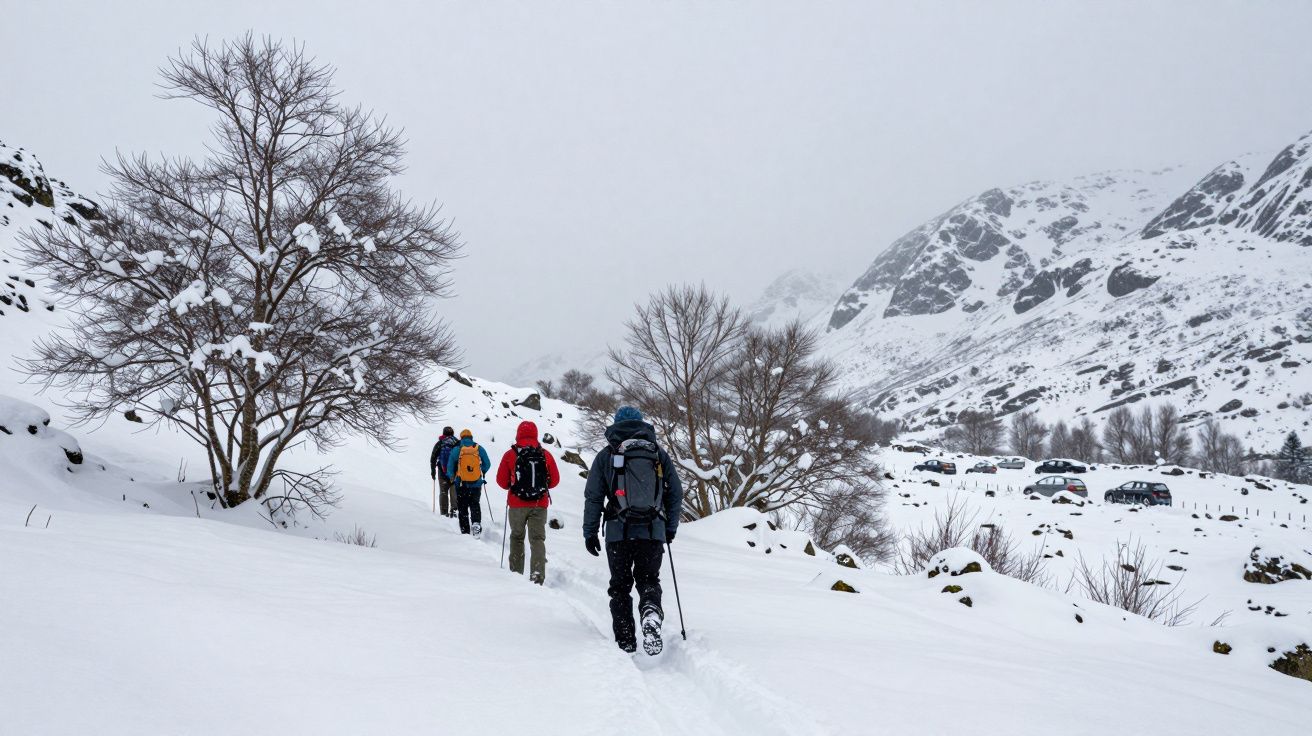
The first sign is not the snow. It is the wind that suddenly tastes different on a November ridge, sharp and powder-dry instead of wet and mild. Corrie rims that were bare last week are now rimed white. By morning, a lay-by in Glen Shiel is full of cars under a sky that looks like steel, their owners halfway up a Munro in knee-deep drifts.
At the same time, maps of the Arctic show something that looks the opposite of winter: blue ocean where there used to be solid ice. Year after year, the late-summer ice edge retreats further north and east. It feels like two stories that cannot both be true: a warming Arctic above, and heavier Highland snowfalls below.
Meteorologists will tell you those stories are not only compatible. In some winters, they are tightly connected.
Melt more ice at the top of the world and, under the right conditions, you prime the atmosphere to dump more snow on Scotland’s mountains.
When a shrinking Arctic sends cold south
The Arctic is warming faster than the rest of the globe. One of the clearest signs is sea ice extent: the frozen lid that once covered vast areas of the Arctic Ocean is thinner, more fractured and retreats earlier in the year.
That missing lid changes how the atmosphere behaves. Open water in autumn and early winter releases heat and moisture into the air that would previously have been trapped under ice. The temperature contrast between the warm ocean and the cold polar night above sharpens.
High above the Atlantic, the polar front jet stream – that fast river of air that steers our storms – responds to those contrasts. In a more “normal” winter it flows in a relatively tight west–east band. With a warmer, patchier Arctic, it can slow and meander, pulling long plumes of air north and south.
For Scotland, those meanders are crucial. When the jet stream buckles, it can park stubborn high pressure over Greenland or Scandinavia. That, in turn, encourages bitter northerly or easterly winds to spill over the UK – winds that can turn the Highlands into a snow magnet.
The jet stream’s new wobble
Meteorologists talk about “blocking patterns”: large, slow-moving pressure systems that jam the usual west-to-east progression of weather. Several studies suggest that low sea ice in specific regions – especially the Barents and Kara Seas north of Scandinavia – makes these blocks more likely in late autumn and winter.
Here is the rough chain they sketch:
Less sea ice, more heat and moisture
Open water pumps warmth and vapour into the lower atmosphere, creating pockets of low pressure and altered temperature gradients.Changed pressure patterns, wavier jet
The boosted heat contrasts help the jet stream meander. Large ridges (bulges of high pressure) and troughs (dips of low pressure) become more pronounced.Greenland or Scandinavian blocking
A ridge may build over Greenland or Scandinavia. That high acts like a boulder in a river, diverting the flow and slowing systems down.Cold air outbreaks towards Scotland
With the block in place, Arctic air is shunted south on the block’s western or southern flank. Northern and eastern Scotland sit squarely in its path.
Not every low-ice year produces this exact pattern; the North Atlantic is too complex for a single-cause story. But when the pieces line up, forecasters know to start thinking about snow rather than only wind and rain.
How missing ice loads Scotland’s “snow cannon”
Cold air alone does not guarantee big snowfalls. The Highlands usually need three ingredients working together:
- Cold, Arctic-sourced air to keep snow from turning to sleet and rain.
- Moisture supply from the Atlantic or North Sea.
- Uplift over terrain, forcing air to rise, cool and drop its load as snow.
Shrinking Arctic sea ice can quietly strengthen two of those ingredients.
First, the Arctic air mass itself can hold more moisture than it used to, simply because it has passed over open, evaporating water rather than dry ice. By the time that air sweeps across the Norwegian Sea and North Sea, it has picked up another layer of humidity.
Second, the altered jet stream often encourages slow-moving or repeated snow showers rather than a single quick front. With a blocking pattern in place, lines of showers can “train” over the same glens and corries for hours. Hillwalkers know these days: the radar shows narrow, bright bands that refuse to move, while snow on leeward slopes piles up alarmingly fast.
The result resembles a maritime version of the “lake-effect” snow off the Great Lakes in North America. There, cold air passing over relatively warm water generates intense, localised snow bands. Over Scotland, the North Sea and Atlantic play a similar role when Arctic air pours down on a bent jet stream.
In a warmer world, individual snowstorms can grow fatter, even as average winter snow cover slowly shrinks.
What forecasters actually look at
When meteorologists brief about a potentially snowy Scottish winter, they are not just glancing at one Arctic map. They juggle a set of signals that, together, tilt the odds.
| Signal | What it tells forecasters | Typical Highland impact |
|---|---|---|
| Autumn Barents–Kara sea-ice extent | How much open water is feeding heat into the Arctic atmosphere | Lower ice can favour later-winter blocking and cold spells |
| North Atlantic Oscillation (NAO) index | Balance between Icelandic low and Azores high | Negative NAO often linked to colder, snowier UK winters |
| Sudden stratospheric warming (SSW) events | Disruptions of the polar vortex high above | Increase risk of prolonged cold outbreaks 2–4 weeks later |
On top of this, they watch day-to-day charts for:
- High pressure building over Greenland or Scandinavia.
- A jet stream displaced well to the south of the British Isles.
- Northerly or easterly surface winds aimed straight at Scotland.
- Bands of showers lining up over the North Sea or Minch.
If those pieces appear while mountain ground temperatures are already low, heavy upland snowfall can arrive with surprisingly little warning for anyone not glued to synoptic charts.
For skiers, stalkers and drivers: what this means on the ground
For people who live, work or play in the Highlands, the Arctic’s missing ice is not an abstract problem. It filters down into questions as simple as: “Will the pass be open on Monday?” or “Is this gully about to avalanche?”
In practical terms, the emerging pattern suggests:
More volatile winters
Fewer long, steady snow seasons at low and mid-levels; more winters that flip rapidly between mild slush and intense, short-lived blizzards.Heavier dump events at higher elevations
When cold spells hit, the atmosphere may hold more moisture. That can translate to deeper fresh snow on summits and lee slopes, increasing avalanche potential.Infrastructure stress
Roads like the A9, A82 and A835 may face fewer snow days overall but more extreme episodes that challenge ploughing and grit stocks.Mixed fortunes for snow sports
Resorts could see fewer “reliable” seasons, yet on good years, the biggest snowfalls may arrive in short, intense bursts that are superb for a few days and then vanish in the next mild spell.
If you walk, ski or guide in the Highlands, the advice from forecasters is simple: follow the patterns, not just the day’s forecast. A winter with severely low Barents–Kara ice and a negative NAO deserves more attention to avalanche reports, route choices and escape plans.
Reading the headlines without getting lost in them
It is tempting to turn this into a tidy story: “Arctic melt means more Scottish snow.” The science is not that neat.
Global warming is making Scotland’s climate milder overall. Long-term records show that snow cover at low elevations is decreasing, and the snow season is shortening. That signal is robust.
The “more heavy snow” narrative lives in a narrower space: specific regions (the Highlands, especially the north and east), specific weather patterns (blocked, northerly or easterly flows) and specific seasons (late autumn to early spring). Within that window, the altered Arctic can load the dice towards more intense individual snowfalls.
Climate models still disagree on exactly how strong this link will be in future decades. Other factors, such as Atlantic sea-surface temperatures and natural variability, can amplify or mute the effect in any given year. Researchers are cautious: they see a plausible chain of influence, supported by observations, but not a simple rule that works every winter.
A useful way to hold it in mind is this:
The Arctic’s vanishing ice is not “good news for snow lovers”. It is one more sign of a disrupted system that sometimes delivers its chaos as a blizzard in Coire an t‑Sneachda.
How you can keep an eye on the pattern
You do not need a meteorology degree to see some of these links yourself. A few habits turn the Arctic from a distant idea into something you can track:
- Check late-summer and autumn Arctic sea-ice maps from reputable sources; note years with especially low Barents–Kara ice.
- Follow seasonal outlooks from the Met Office and academic groups, which increasingly mention Arctic conditions alongside the NAO.
- In winter, watch for forecasts of “blocking highs” near Greenland or Scandinavia and prolonged northerly/easterly winds.
- Pair that information with local avalanche forecasts and mountain observations rather than treating a snowier signal as automatically good news.
Over time, a pattern will emerge. Some low-ice years will pass with barely a flurry. Others will deliver that sudden switch on a November ridge, when the wind feels powder-dry and the Highlands once again remind you how close they are, in spirit, to the top of the world.
FAQ:
- How can global warming lead to heavier snowfalls?
Warmer air can hold more moisture. When that moist air meets a strong blast of cold – especially over mountains – it can release larger amounts of snow in a short time, even though the overall number of snowy days may be falling.- Does this mean Scottish ski seasons will get better?
Not in a simple, reliable way. There may be more extreme “powder days” in some years, but also more rain-at-all-levels events and thin starts or abrupt ends to the season as temperatures trend upwards.- Is the link between Arctic sea ice and Highland snow proven?
There is growing evidence of a connection, particularly involving low Barents–Kara sea ice, jet stream waviness and UK cold spells. However, the atmosphere is noisy, and researchers stress that Arctic change is one influence among several, not a guaranteed trigger.- Should Scottish councils plan differently for winter now?
Many already are. The emerging picture argues for flexible planning: equipment and budgets that can cope both with milder winters and with occasional, high-impact snow events that cause short, sharp disruption.


Comments (0)
No comments yet. Be the first to comment!
Leave a Comment